Joe Ben Sanders Historic Map of Old La Luz, NM (1863–1883) View Watchlist >
- Winning Bid: $265.00
- 36 Bid(s) View Bid History
- High Bidder: justd
Seller Accepts Credit Cards
Payment and pickup instructions will be available on your invoice (under "My Account") at the conclusion of this auction.
Lot # C986
System ID # 21809500
Start Date
End Date
1 Watching
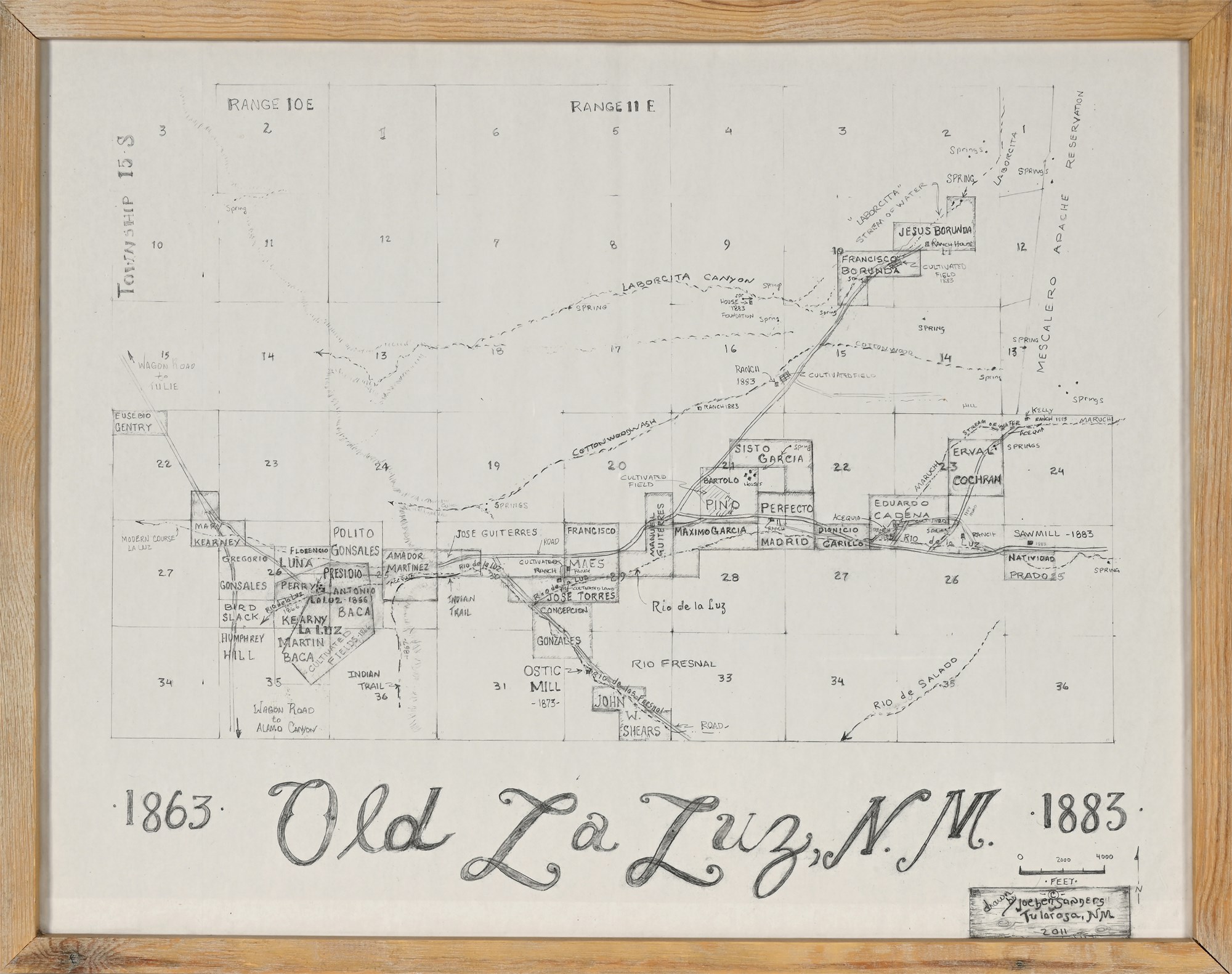
Joe Ben Sanders Historic Map of Old La Luz, NM (1863–1883)
This hand-drawn historic map presents a richly detailed view of Old La Luz, New Mexico, as it appeared between 1863 and 1883. Created in 2011 by regional archaeologist and historian Joe Ben Sanders of Tularosa, NM, the map is based on extensive historical and cultural research. Sanders, known for his work documenting rock art and historic settlements in the Tularosa Basin, captures the early territorial land divisions and family holdings with precision and care.
Rendered entirely in pencil and signed by the artist in the lower right, the map shows named landowners, Indian trails, wagon roads, cultivated fields, rivers, and adjacent areas including the Mescalero Apache Reservation. Notable figures such as Borunda, Baca, Gutierres, and Torres are prominently featured, making this a compelling artifact for researchers and descendants alike.
Presented under plexiglass in a rustic wood frame, this piece is both decorative and educational—a testament to New Mexico’s 19th-century land heritage. Whether for display in a home, office, or institutional collection, it serves as a meaningful conversation piece rooted in deep regional history.
Condition:
In good condition overall. The drawing surface shows original fold creases, consistent with the archival map style. The wood frame displays minor chips and surface wear, with scuffing to corners. Plexiglass cover is clean and intact. Stable and ready to hang.
Materials:
• Graphite pencil on paper
• Natural wood frame
• Plexiglass glazing
• Signed “Joe Ben Sanders, Tularosa, NM, 2011” in lower right
Dimensions:
Overall (framed): 23 1/2" x 29 1/2"
Visible image: 21" x 27"
Additional Notes:
Joe Ben Sanders is a respected New Mexico archaeologist and preservationist whose work spans over two decades. He has led public education efforts on regional petroglyphs and conducted extensive historical mapping tied to early settlement patterns in Otero County. This map reflects his dedication to historical accuracy and regional storytelling.